IMAGES TAKEN NEAR TO
DALRY, KA24 4JW
Introduction
This page details the photographs taken nearby to KA24 4JW by members of the Geograph project.
The Geograph project started in 2005 with the aim of publishing, organising and preserving representative images for every square kilometre of Great Britain, Ireland and the Isle of Man.

There are currently over 7.5m images from over14,400 individuals and you can help contribute to the project by visiting https://www.geograph.org.uk
Image Map
Images are licensed for reuse under creativecommons.org/licenses/by-sa/2.0
Notes
- Clicking on the map will re-center to the selected point.
- The higher the marker number, the further away the image location is from the centre of the postcode.
Image Listing (7 Images Found)
Images are licensed for reuse under creativecommons.org/licenses/by-sa/2.0
Image
Details
Distance
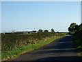
2
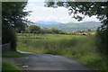
Yellow road, Muirhouse
The road passes a bing and colliery site with a view of Arran in the background.
Image: © Richard Webb
Taken: 1 Sep 2015
0.19 miles
4
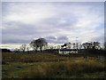
Cottage
Rural cottage situated at the only road junction in this grid square.
Image: © Chris Court
Taken: 25 Nov 2005
0.21 miles
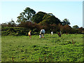
6
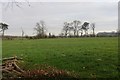
Field near Swindridge Muir
There were once coal mines here.
Image: © Richard Webb
Taken: 15 Nov 2014
0.24 miles
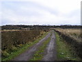
7
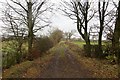
Green lane near Wheatyfauld
A substantial road, probably a legacy from the coal mining era here.
Image: © Richard Webb
Taken: 15 Nov 2014
0.24 miles