IMAGES TAKEN NEAR TO
Beith Road, DALRY, KA24 4JP
Introduction
This page details the photographs taken nearby to Beith Road, KA24 4JP by members of the Geograph project.
The Geograph project started in 2005 with the aim of publishing, organising and preserving representative images for every square kilometre of Great Britain, Ireland and the Isle of Man.

There are currently over 7.5m images from over14,400 individuals and you can help contribute to the project by visiting https://www.geograph.org.uk
Image Map
Images are licensed for reuse under creativecommons.org/licenses/by-sa/2.0
Notes
- Clicking on the map will re-center to the selected point.
- The higher the marker number, the further away the image location is from the centre of the postcode.
Image Listing (5 Images Found)
Images are licensed for reuse under creativecommons.org/licenses/by-sa/2.0
Image
Details
Distance
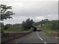
2
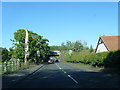
A737 Beith Road nearing railway overbridge
Image: © Colin Pyle
Taken: 10 Jun 2015
0.16 miles
3
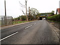
Rail Bridge Dalry
On the A737 Dalry to Beith road the bridge carries the lines for the Glasgow to Ayrshire coast trains.
Image: © Gordon Dowie
Taken: 27 Apr 2010
0.16 miles
4
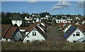
Mill Park, Dalry
New houses on the east side of Dalry, north of the railway station. Viewed from and Ayr bound train.
Image: © Thomas Nugent
Taken: 9 Apr 2013
0.17 miles
5
A737 approaching railway bridge in Dalry
Image: © John Firth
Taken: 27 Jul 2012
0.21 miles