IMAGES TAKEN NEAR TO
Crossroads, DALRY, KA24 4JF
Introduction
This page details the photographs taken nearby to Crossroads, KA24 4JF by members of the Geograph project.
The Geograph project started in 2005 with the aim of publishing, organising and preserving representative images for every square kilometre of Great Britain, Ireland and the Isle of Man.

There are currently over 7.5m images from over14,400 individuals and you can help contribute to the project by visiting https://www.geograph.org.uk
Image Map
Images are licensed for reuse under creativecommons.org/licenses/by-sa/2.0
Notes
- Clicking on the map will re-center to the selected point.
- The higher the marker number, the further away the image location is from the centre of the postcode.
Image Listing (5 Images Found)
Images are licensed for reuse under creativecommons.org/licenses/by-sa/2.0
Image
Details
Distance
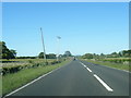
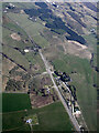
1
The A737 Dalry bypass from the air
Looking towards The Den, between Dalry and Beith.
Image: © Thomas Nugent
Taken: 21 Apr 2022
0.03 miles
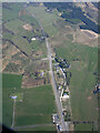
2
The Graze restaurant just south of the Den
A737 south
Image: © John Firth
Taken: 27 Jul 2012
0.06 miles
3
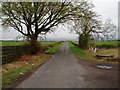
Road to Davidshill
Single track road off the A737 Beith to Dalry road.
Image: © Gordon Dowie
Taken: 27 Apr 2010
0.12 miles
4
The A77 Dalry bypass from the air
At The Den, between Dalry and Beith.
Image: © Thomas Nugent
Taken: 21 Apr 2022
0.12 miles