IMAGES TAKEN NEAR TO
DALRY, KA24 4HR
Introduction
This page details the photographs taken nearby to KA24 4HR by members of the Geograph project.
The Geograph project started in 2005 with the aim of publishing, organising and preserving representative images for every square kilometre of Great Britain, Ireland and the Isle of Man.

There are currently over 7.5m images from over14,400 individuals and you can help contribute to the project by visiting https://www.geograph.org.uk
Image Map
Images are licensed for reuse under creativecommons.org/licenses/by-sa/2.0
Notes
- Clicking on the map will re-center to the selected point.
- The higher the marker number, the further away the image location is from the centre of the postcode.
Image Listing (12 Images Found)
Images are licensed for reuse under creativecommons.org/licenses/by-sa/2.0
Image
Details
Distance
2
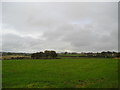
Green Field
Farmland looking east towards the A737 and Birkentop Cottage.
Image: © Chris Court
Taken: 2 Oct 2005
0.10 miles
4
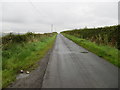
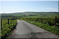
Lane from Highfield to Longbar
Looking north-eastward.
Image: © Peter Wood
Taken: 13 Sep 2016
0.15 miles
5
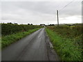
Lane from Longbar to Highfield
Looking south-westward.
Image: © Peter Wood
Taken: 13 Sep 2016
0.15 miles
6
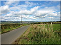
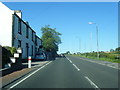
Auchengree road
Country road which leads from Highfield to Auchengree on the East side of the Garnock Valley.
Image: © wfmillar
Taken: 22 Sep 2008
0.18 miles
8
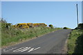
Gorse beside the road
In full flower in the hedge.
Image: © Richard Sutcliffe
Taken: 14 May 2016
0.21 miles
9
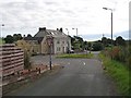
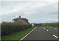
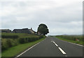
Highfield
Highfield seen from the minor road that carries National Cycle Route 7. The road is signed as a quiet route with a non mandatory 30mph speed limit. In reality it is a lethal rat run with a rat behind every blind bend, especially the section south of Highfield. Bad enough on a bike, but at least you can hear them coming. Not a road I intend driving.
The large house on the main road (A737) looks like it may once have been a public house.
Image: © Richard Webb
Taken: 13 Aug 2009
0.22 miles