IMAGES TAKEN NEAR TO
Highfield Cottages, DALRY, KA24 4HN
Introduction
This page details the photographs taken nearby to Highfield Cottages, KA24 4HN by members of the Geograph project.
The Geograph project started in 2005 with the aim of publishing, organising and preserving representative images for every square kilometre of Great Britain, Ireland and the Isle of Man.

There are currently over 7.5m images from over14,400 individuals and you can help contribute to the project by visiting https://www.geograph.org.uk
Image Map
Images are licensed for reuse under creativecommons.org/licenses/by-sa/2.0
Notes
- Clicking on the map will re-center to the selected point.
- The higher the marker number, the further away the image location is from the centre of the postcode.
Image Listing (10 Images Found)
Images are licensed for reuse under creativecommons.org/licenses/by-sa/2.0
Image
Details
Distance
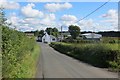
1
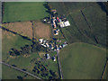
Bellstone and Kerslochmuir from the air
By the B707 at Highfield, Bellstone is nearer the camera.
Image: © Thomas Nugent
Taken: 25 Sep 2017
0.05 miles
2
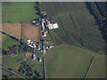
Bellstone and Kerslochmuir from the air
By the B707 at Highfield, Bellstone is nearer the camera.
Image: © Thomas Nugent
Taken: 25 Sep 2017
0.07 miles
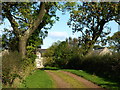
6
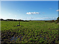
Grazing, near Highfield
View towards the pharmaceutical works at Dalry.
Image: © wfmillar
Taken: 3 Oct 2008
0.18 miles
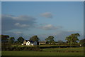
7
Grazing, near Highfield
Unusual to find the watering trough well into the field.
Image: © wfmillar
Taken: 3 Oct 2008
0.19 miles
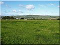
8
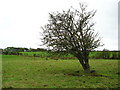
Old Tree
This old thorn bush in the middle of the pasture appears to be on its last legs.
Image: © Chris Court
Taken: 2 Oct 2005
0.22 miles