IMAGES TAKEN NEAR TO
DALRY, KA24 4HH
Introduction
This page details the photographs taken nearby to KA24 4HH by members of the Geograph project.
The Geograph project started in 2005 with the aim of publishing, organising and preserving representative images for every square kilometre of Great Britain, Ireland and the Isle of Man.

There are currently over 7.5m images from over14,400 individuals and you can help contribute to the project by visiting https://www.geograph.org.uk
Image Map
Images are licensed for reuse under creativecommons.org/licenses/by-sa/2.0
Notes
- Clicking on the map will re-center to the selected point.
- The higher the marker number, the further away the image location is from the centre of the postcode.
Image Listing (7 Images Found)
Images are licensed for reuse under creativecommons.org/licenses/by-sa/2.0
Image
Details
Distance
1
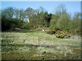
Disused Pit
Disused Blair Colliery looking west towards Bowertrapping which can just be seen through the trees in the top left quarter of this photo
Image: © Ian Rainey
Taken: 28 Apr 2006
0.06 miles
2
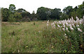
Disused Pit
Practically no sign of the Blair Colliery.
Image: © wfmillar
Taken: 26 Sep 2008
0.10 miles
3
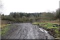
Blair Colliery site
It has the appearance of a quarry, no buildings survive.
Image: © Richard Webb
Taken: 15 Nov 2014
0.10 miles
5
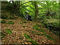
Early Autumn
These must be last year's leaves!
Image: © wfmillar
Taken: 26 Sep 2008
0.15 miles
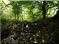
6
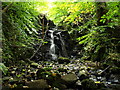
Small Waterfall
Unnamed burn only a few yards from the roadside but totally hidden.
Image: © wfmillar
Taken: 26 Sep 2008
0.16 miles
7
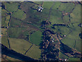
Bowertrapping from the air
Knollhead Farm is near the top of the photo.
Image: © Thomas Nugent
Taken: 28 Jan 2019
0.17 miles