IMAGES TAKEN NEAR TO
DALRY, KA24 4EW
Introduction
This page details the photographs taken nearby to KA24 4EW by members of the Geograph project.
The Geograph project started in 2005 with the aim of publishing, organising and preserving representative images for every square kilometre of Great Britain, Ireland and the Isle of Man.

There are currently over 7.5m images from over14,400 individuals and you can help contribute to the project by visiting https://www.geograph.org.uk
Image Map
Images are licensed for reuse under creativecommons.org/licenses/by-sa/2.0
Notes
- Clicking on the map will re-center to the selected point.
- The higher the marker number, the further away the image location is from the centre of the postcode.
Image Listing (17 Images Found)
Images are licensed for reuse under creativecommons.org/licenses/by-sa/2.0
Image
Details
Distance
5
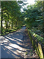
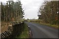
Moss covered wall
This wall surrounds the Blair estate. The minor road leads to Kilwinning.
Image: © wfmillar
Taken: 23 Sep 2008
0.17 miles
6
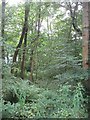
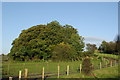
Woodland, Blair
A keek over the Blair policy wall. Broadleafed woodland.
Image: © Richard Webb
Taken: 13 Aug 2009
0.18 miles
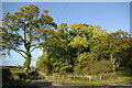
8
Woodland, Blair
Young trees in the policies of Blair.
Image: © Richard Webb
Taken: 15 Nov 2014
0.20 miles
9
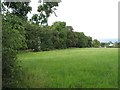
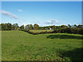
Grassland near Blair
Long grass, probably due for harvesting as a second cut of silage.
Image: © Richard Webb
Taken: 13 Aug 2009
0.20 miles
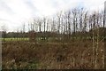
10
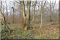
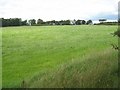
Templandmuir Wood
Broadleaved woodland in a landscape of farmland and scattered woods.
Image: © Richard Webb
Taken: 15 Nov 2014
0.22 miles