IMAGES TAKEN NEAR TO
DALRY, KA24 4EP
Introduction
This page details the photographs taken nearby to KA24 4EP by members of the Geograph project.
The Geograph project started in 2005 with the aim of publishing, organising and preserving representative images for every square kilometre of Great Britain, Ireland and the Isle of Man.

There are currently over 7.5m images from over14,400 individuals and you can help contribute to the project by visiting https://www.geograph.org.uk
Image Map (10 Images)


Getting Data...Please wait
Leaflet Map data © OpenStreetMap
Images are licensed for reuse under creativecommons.org/licenses/by-sa/2.0
Notes
- Clicking on the map will re-center to the selected point.
- The higher the marker number, the further away the image location is from the centre of the postcode.
Image Listing (10 Images Found)
Images are licensed for reuse under creativecommons.org/licenses/by-sa/2.0
Image
Details
Distance
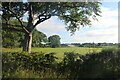
3
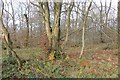
Templandmuir Wood
Broadleaved woodland in a landscape of farmland and scattered woods.
Image: © Richard Webb
Taken: 15 Nov 2014
0.17 miles
4
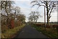
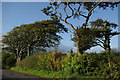
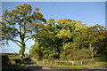
Minor road, Templandmuir
Passing Templandmuir Wood.
Image: © Richard Webb
Taken: 15 Nov 2014
0.17 miles
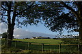
5
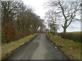
Lane near Templandmuir Farm
Looking east along a lane south of Templandmuir Farm as it passes a small wood.
Image: © Mark Nightingale
Taken: 23 Mar 2010
0.20 miles
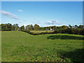
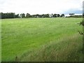
8
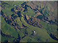
Cleeves from the air
Foxcover Plantation is prominent in the centre.
Image: © Thomas Nugent
Taken: 28 Jan 2019
0.23 miles