IMAGES TAKEN NEAR TO
DALRY, KA24 4EL
Introduction
This page details the photographs taken nearby to KA24 4EL by members of the Geograph project.
The Geograph project started in 2005 with the aim of publishing, organising and preserving representative images for every square kilometre of Great Britain, Ireland and the Isle of Man.

There are currently over 7.5m images from over14,400 individuals and you can help contribute to the project by visiting https://www.geograph.org.uk
Image Map
Images are licensed for reuse under creativecommons.org/licenses/by-sa/2.0
Notes
- Clicking on the map will re-center to the selected point.
- The higher the marker number, the further away the image location is from the centre of the postcode.
Image Listing (5 Images Found)
Images are licensed for reuse under creativecommons.org/licenses/by-sa/2.0
Image
Details
Distance
1

Stoopshill
Stoopshill sits east of Dalry, just northwest of the perimeter wall of the grounds of Blair Castle.
Image: © Mark Nightingale
Taken: 23 Mar 2010
0.03 miles
2
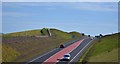
Dalry Bypass, North Ayrshire
Construction of the Dalry Bypass began in July 2017 and opened to traffic on the 30th May 2019, some seven months ahead of schedule. The new road will help to ease congestion in the town of Dalry and improve journey times to surrounding areas.
As of June 2019, contractors remain on site to construct the connecting road between the existing A737 and the new roundabout at Highfield.
Image: © Mark S
Taken: 22 Jun 2019
0.12 miles
3

Dalry Bypass, North Ayrshire
Construction of the Dalry Bypass began in July 2017 and opened to traffic on the 30th May 2019, some seven months ahead of schedule. The new road will help to ease congestion in the town of Dalry and improve journey times to surrounding areas.
As of June 2019, contractors remain on site to construct the connecting road between the existing A737 and the new roundabout at Highfield.
Image: © Mark S
Taken: 22 Jun 2019
0.12 miles
4
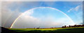
Stoopshill Rainbow
Looking over the fields of Stoopshill farm toward Peasweep Mount.
Image: © Scott Eden
Taken: 19 Nov 2010
0.16 miles
5
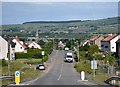
Dalry, North Ayrshire
Dalry, seen here from Blair Road.
Kelburn Wind Farm is to the top right.
Image: © Mark S
Taken: 22 Jun 2019
0.21 miles