IMAGES TAKEN NEAR TO
Bridgend, DALRY, KA24 4DB
Introduction
This page details the photographs taken nearby to Bridgend, KA24 4DB by members of the Geograph project.
The Geograph project started in 2005 with the aim of publishing, organising and preserving representative images for every square kilometre of Great Britain, Ireland and the Isle of Man.

There are currently over 7.5m images from over14,400 individuals and you can help contribute to the project by visiting https://www.geograph.org.uk
Image Map
Images are licensed for reuse under creativecommons.org/licenses/by-sa/2.0
Notes
- Clicking on the map will re-center to the selected point.
- The higher the marker number, the further away the image location is from the centre of the postcode.
Image Listing (30 Images Found)
Images are licensed for reuse under creativecommons.org/licenses/by-sa/2.0
Image
Details
Distance
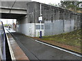
2
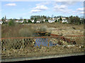
The River Garnock in Dalry
A scene of industrial dereliction, viewed from an Ayr bound train.
Image: © Thomas Nugent
Taken: 9 Apr 2013
0.07 miles
4
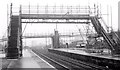
Dalry station (1985)
For a short history of Dalry station, in particular the platforms, see http://en.wikipedia.org/wiki/Dalry_railway_station. This view, towards Glasgow, shows the station under reconstruction as part of the Ayrshire electrification. At the time of submission there were no photographs of the station to allow a “then and now” comparison.
Image: © Albert Bridge
Taken: 21 Mar 1985
0.09 miles
6
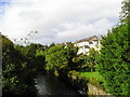
Dalry
The River Garnock which rises on the moors at Muirshiel Country Park before meandering its way to the sea at Irvine. This picture includes tenements and gardens in Dalry backing onto the river.
Image: © Chris Court
Taken: 29 Sep 2005
0.09 miles
7

Dalry station, 1996
View southward, towards Ayr and Ardrossan, also formerly Crosshouse: ex-Glasgow & South Western main line to Ayr etc., electrified 9/86-1/87; the line to Crosshouse and Kilmarnock was closed 22/10/73.
Image: © Ben Brooksbank
Taken: 8 Jul 1996
0.10 miles
8

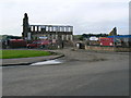
Dalry - East Kirkland estate 1993
Newly built housing estate, typical of the era in design and layout, complete with block paving.
Image: © Peter Whatley
Taken: Unknown
0.10 miles
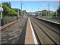
9
Dalry railway station
The Glasgow bound platform, viewed from an Ayr bound train.
Image: © Thomas Nugent
Taken: 8 Aug 2022
0.10 miles
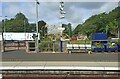
10
Dalry railway station, Ayrshire
Opened in 1840 by the Glasgow, Paisley, Kilmarnock & Ayr Railway on the far side of the road bridge, the station was relocated to south of the road bridge in 1878 by the GPKAR's successor, the Glasgow & South Western Railway.
View north towards Glengarnock and Glasgow. Between 1905 and the 1980s, each platform had two sides, making four platforms in total. The line was electrified in 1986.
Image: © Nigel Thompson
Taken: 4 Oct 2013
0.10 miles