IMAGES TAKEN NEAR TO
Garnock Street, DALRY, KA24 4BS
Introduction
This page details the photographs taken nearby to Garnock Street, KA24 4BS by members of the Geograph project.
The Geograph project started in 2005 with the aim of publishing, organising and preserving representative images for every square kilometre of Great Britain, Ireland and the Isle of Man.

There are currently over 7.5m images from over14,400 individuals and you can help contribute to the project by visiting https://www.geograph.org.uk
Image Map
Images are licensed for reuse under creativecommons.org/licenses/by-sa/2.0
Notes
- Clicking on the map will re-center to the selected point.
- The higher the marker number, the further away the image location is from the centre of the postcode.
Image Listing (73 Images Found)
Images are licensed for reuse under creativecommons.org/licenses/by-sa/2.0
Image
Details
Distance
1
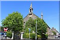
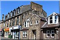
St Palladius' RC Church, Aitken Street, Dalry
Built 1851
Image: © Leslie Barrie
Taken: 16 May 2014
0.05 miles
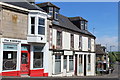
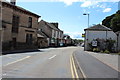
2
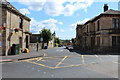
Royal Hotel, Dalry
Category B-listed. Early 19th century. On the corner of New Street and Garnock Street. Viewed here on Garnock Street.
Image: © Leslie Barrie
Taken: 16 May 2014
0.08 miles
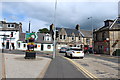
6
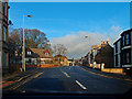
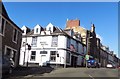
A737, Dalry
Waiting at the traffic lights. Roche Way on the left of Townend Street. Post Office to the left of the black car.
Image: © wfmillar
Taken: 23 Jan 2012
0.10 miles