IMAGES TAKEN NEAR TO
WEST KILBRIDE, KA23 9PX
Introduction
This page details the photographs taken nearby to KA23 9PX by members of the Geograph project.
The Geograph project started in 2005 with the aim of publishing, organising and preserving representative images for every square kilometre of Great Britain, Ireland and the Isle of Man.

There are currently over 7.5m images from over14,400 individuals and you can help contribute to the project by visiting https://www.geograph.org.uk
Image Map
Images are licensed for reuse under creativecommons.org/licenses/by-sa/2.0
Notes
- Clicking on the map will re-center to the selected point.
- The higher the marker number, the further away the image location is from the centre of the postcode.
Image Listing (8 Images Found)
Images are licensed for reuse under creativecommons.org/licenses/by-sa/2.0
Image
Details
Distance
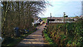
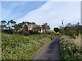
2
West Kilbride, Crosbie Mains Farm
With Arran in the background.
Image: © william craig
Taken: 20 Feb 2007
0.03 miles
3
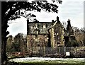
Crosbie Castle (Crosbie Towers) - West Kilbride
Description
A 17th century house on site of earlier keep; T plan, consisting of a crow-stepped gabled oblong with projecting staircase tower having a small watchroom at the top; 3 storeys and attic; door is in the west side of the tower. Restored in late 19th century and originally contained some good chimneypieces and panelling. (Historic Scotland).
Crosbie Castle otherwise known as Crosbie Towers is on the outskirts of West Kilbride. The home of Sir Ranauld Craufurd during the 13th century and was rebuilt in the 17th century after a tower was demolished. It is not inhabited today and was semi-demolished in 2007 after storm damage to the external walls of the castle.
It was used as Crosbie Youth Hostel during the 1970's.
Crosbie Towers is Category B Listed and is on the Buildings at Risk Register of Scotland.
Image: © Raibeart MacAoidh
Taken: 20 Jan 2018
0.11 miles
4
Crosbie Castle (Crosbie Towers) - West Kilbride
Description
A 17th century house on site of earlier keep; T plan, consisting of a crow-stepped gabled oblong with projecting staircase tower having a small watchroom at the top; 3 storeys and attic; door is in the west side of the tower. Restored in late 19th century and originally contained some good chimneypieces and panelling. (Historic Scotland).
Crosbie Castle otherwise known as Crosbie Towers is on the outskirts of West Kilbride. The home of Sir Ranauld Craufurd during the 13th century and was rebuilt in the 17th century after a tower was demolished. It is not inhabited today and was semi-demolished in 2007 after storm damage to the external walls of the castle.
Crosbie Towers was a former youth hostel.
Crosbie Towers is Category B Listed and is on the Buildings at Risk Register of Scotland.
Image: © Raibeart MacAoidh
Taken: 20 Jan 2018
0.11 miles
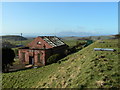
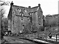
6
Crosbie Waterworks
Disused waterworks building at Crosbie Reservoir
Image: © Raibeart MacAoidh
Taken: 3 Oct 2016
0.22 miles
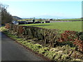
7
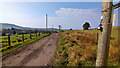
The track to Crosbie Mains farm
The pole is fitted with monitoring devices. See https://www.geograph.org.uk/photo/7133003 for more information.
Image: © Gordon Brown
Taken: 29 Mar 2022
0.23 miles
8
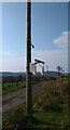
Monitoring device on the power pole
The pole is marked "Boron treated 2013" and has a device with tag attached saying "Jacobs magnox DO NOT INTERFERE Call Jacobs/Magnox on [Phone No quoted]".
This is presumably ongoing monitoring associated with the nearby Hunterston A Magnox Nuclear Power Station, currently being decommissioned.
See also https://www.geograph.org.uk/photo/7133002
Image: © Gordon Brown
Taken: 29 Mar 2022
0.25 miles