IMAGES TAKEN NEAR TO
WEST KILBRIDE, KA23 9PQ
Introduction
This page details the photographs taken nearby to KA23 9PQ by members of the Geograph project.
The Geograph project started in 2005 with the aim of publishing, organising and preserving representative images for every square kilometre of Great Britain, Ireland and the Isle of Man.

There are currently over 7.5m images from over14,400 individuals and you can help contribute to the project by visiting https://www.geograph.org.uk
Image Map
Images are licensed for reuse under creativecommons.org/licenses/by-sa/2.0
Notes
- Clicking on the map will re-center to the selected point.
- The higher the marker number, the further away the image location is from the centre of the postcode.
Image Listing (8 Images Found)
Images are licensed for reuse under creativecommons.org/licenses/by-sa/2.0
Image
Details
Distance
1
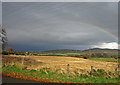
Barley Field
Another partially cropped field. The patch near the centre has been left as the ground is too wet.
Image: © wfmillar
Taken: 21 Oct 2008
0.10 miles
2
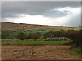
Barley Field
Again too wet to finish the harvesting . The train is heading to Largs on the Ardrossan/Largs line. Crosbie Hills in the distance.
Image: © wfmillar
Taken: 21 Oct 2008
0.13 miles
3
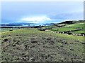
Drummilling Hill - West Kilbride
Looking towards Hunterston Terminal from the summit of Drummilling Hill
Image: © Raibeart MacAoidh
Taken: 15 Jan 2018
0.14 miles
5
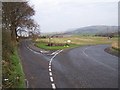
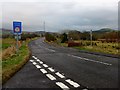
West Kilbride, Junction
a view from the west side
Image: © william craig
Taken: 18 Nov 2005
0.16 miles
6
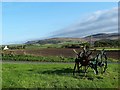
Old Potato Digger
Looking towards Caldron Hill from the B781 junction
Image: © Raibeart MacAoidh
Taken: 5 Oct 2016
0.16 miles
7
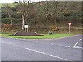
Welcome to West Kilbride
Old tattie howker? at the B781 road junction
Image: © william craig
Taken: 18 Nov 2005
0.17 miles
8
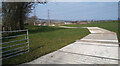
Temporary track across the field
This track is to give access for heavy vehicles to the railway embankment where a water conduit is causing serious flooding and erosion problems.
Image: © Gordon Brown
Taken: 29 Mar 2022
0.18 miles