IMAGES TAKEN NEAR TO
WEST KILBRIDE, KA23 9NX
Introduction
This page details the photographs taken nearby to KA23 9NX by members of the Geograph project.
The Geograph project started in 2005 with the aim of publishing, organising and preserving representative images for every square kilometre of Great Britain, Ireland and the Isle of Man.

There are currently over 7.5m images from over14,400 individuals and you can help contribute to the project by visiting https://www.geograph.org.uk
Image Map
Images are licensed for reuse under creativecommons.org/licenses/by-sa/2.0
Notes
- Clicking on the map will re-center to the selected point.
- The higher the marker number, the further away the image location is from the centre of the postcode.
Image Listing (4 Images Found)
Images are licensed for reuse under creativecommons.org/licenses/by-sa/2.0
Image
Details
Distance
1
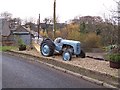
Old Tractor
next to the railway bridge
Image: © william craig
Taken: 18 Nov 2005
0.01 miles
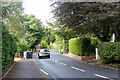
3

West Kilbride: view from the Arran ferry
Looking across the sea from the Ardrossan-Brodick ferry in inclement weather, towards the town of West Kilbride a few miles north.
Image: © Chris Downer
Taken: 27 Sep 2010
0.17 miles
4
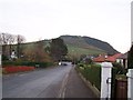
West Kilbride, Meadowfoot Road
With Tarbert Hill in the background.
Image: © william craig
Taken: 18 Nov 2005
0.21 miles