IMAGES TAKEN NEAR TO
Aiknut Road, WEST KILBRIDE, KA23 9LG
Introduction
This page details the photographs taken nearby to Aiknut Road, KA23 9LG by members of the Geograph project.
The Geograph project started in 2005 with the aim of publishing, organising and preserving representative images for every square kilometre of Great Britain, Ireland and the Isle of Man.

There are currently over 7.5m images from over14,400 individuals and you can help contribute to the project by visiting https://www.geograph.org.uk
Image Map
Images are licensed for reuse under creativecommons.org/licenses/by-sa/2.0
Notes
- Clicking on the map will re-center to the selected point.
- The higher the marker number, the further away the image location is from the centre of the postcode.
Image Listing (32 Images Found)
Images are licensed for reuse under creativecommons.org/licenses/by-sa/2.0
Image
Details
Distance
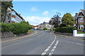
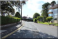
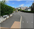
1
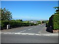
Overton Drive, West Kilbride
From Yerton Brae.
Image: © Stephen Sweeney
Taken: 27 Jul 2011
0.10 miles

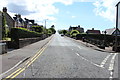
9
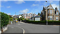
Crossroad in West Kilbride
Looking from Fullerton Drive, across the A78 Kinnin Brae/Ardrossan Road to the B781 Yerton Brae.
Image: © Thomas Nugent
Taken: 8 May 2020
0.14 miles
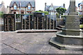
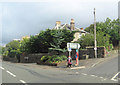
10
Tactile paving on Fullerton Drive
At the pedestrian crossing at the A78 crossroads.
Image: © Thomas Nugent
Taken: 8 May 2020
0.14 miles