IMAGES TAKEN NEAR TO
Nethermiln Road, WEST KILBRIDE, KA23 9EA
Introduction
This page details the photographs taken nearby to Nethermiln Road, KA23 9EA by members of the Geograph project.
The Geograph project started in 2005 with the aim of publishing, organising and preserving representative images for every square kilometre of Great Britain, Ireland and the Isle of Man.

There are currently over 7.5m images from over14,400 individuals and you can help contribute to the project by visiting https://www.geograph.org.uk
Image Map
Images are licensed for reuse under creativecommons.org/licenses/by-sa/2.0
Notes
- Clicking on the map will re-center to the selected point.
- The higher the marker number, the further away the image location is from the centre of the postcode.
Image Listing (20 Images Found)
Images are licensed for reuse under creativecommons.org/licenses/by-sa/2.0
Image
Details
Distance
4
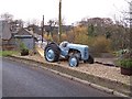
Old Tractor
next to the railway bridge
Image: © william craig
Taken: 18 Nov 2005
0.24 miles
7
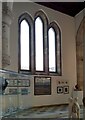
Inside the Barony Centre
The centre Image houses exhibitions, has a gallery and shop, cafe, and some craft studios.
Image: © Richard Sutcliffe
Taken: 11 May 2021
0.24 miles
8
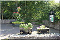
Floral Display at West Kilbride Glen
Image: © Billy McCrorie
Taken: 19 Aug 2014
0.25 miles
9
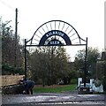
Kilbride Glen
The entrance to the Glen at the B781 Main Street.
Image: © Thomas Nugent
Taken: 8 Nov 2023
0.25 miles
10
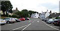
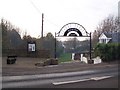
West Kilbride railway station car park
With Curbieshaw Street in the background.
Image: © Thomas Nugent
Taken: 14 Jul 2018
0.25 miles