IMAGES TAKEN NEAR TO
ARDROSSAN, KA22 8PL
Introduction
This page details the photographs taken nearby to KA22 8PL by members of the Geograph project.
The Geograph project started in 2005 with the aim of publishing, organising and preserving representative images for every square kilometre of Great Britain, Ireland and the Isle of Man.

There are currently over 7.5m images from over14,400 individuals and you can help contribute to the project by visiting https://www.geograph.org.uk
Image Map
Images are licensed for reuse under creativecommons.org/licenses/by-sa/2.0
Notes
- Clicking on the map will re-center to the selected point.
- The higher the marker number, the further away the image location is from the centre of the postcode.
Image Listing (4 Images Found)
Images are licensed for reuse under creativecommons.org/licenses/by-sa/2.0
Image
Details
Distance
1
Hauplands Farm
Looking towards Hauplands Farm
Image: © Raibeart MacAoidh
Taken: 5 Oct 2016
0.03 miles
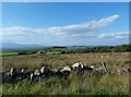
2

Hauplands farm roadend
The turbines of the Ardrossan Wind Farm in the distance.
Image: © Gordon Brown
Taken: 18 Jan 2022
0.04 miles
3
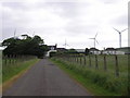
Hauplands Farm
Hauplands Farm and cottages with the Ardrossan wind farm on Busbie Muir in the background
Image: © Ian Rainey
Taken: 13 Jun 2006
0.09 miles