IMAGES TAKEN NEAR TO
Mariners View, ARDROSSAN, KA22 8BF
Introduction
This page details the photographs taken nearby to Mariners View, KA22 8BF by members of the Geograph project.
The Geograph project started in 2005 with the aim of publishing, organising and preserving representative images for every square kilometre of Great Britain, Ireland and the Isle of Man.

There are currently over 7.5m images from over14,400 individuals and you can help contribute to the project by visiting https://www.geograph.org.uk
Image Map
Images are licensed for reuse under creativecommons.org/licenses/by-sa/2.0
Notes
- Clicking on the map will re-center to the selected point.
- The higher the marker number, the further away the image location is from the centre of the postcode.
Image Listing (233 Images Found)
Images are licensed for reuse under creativecommons.org/licenses/by-sa/2.0
Image
Details
Distance
2
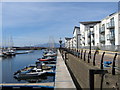
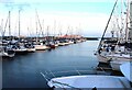
New flats in Ardrossan
Across the marina from the ferry terminal.
Image: © Stephen Sweeney
Taken: 20 Jun 2010
0.03 miles
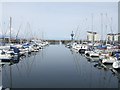
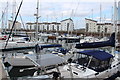
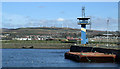
8
Ardrossan Harbour
The outher harbour and the tower.
Image: © Thomas Nugent
Taken: 9 Apr 2013
0.08 miles
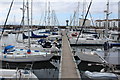
9
Ardrossan Harbour
The outer harbour and the tower.
Image: © Thomas Nugent
Taken: 9 Apr 2013
0.08 miles
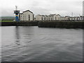
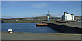
10
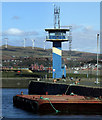
Ardrossan Harbour
The control tower at the enrtrance to what is now the Clyde Marina.
Image: © Thomas Nugent
Taken: 9 Apr 2013
0.08 miles