IMAGES TAKEN NEAR TO
Stormlight Road, ARDROSSAN, KA22 8AE
Introduction
This page details the photographs taken nearby to Stormlight Road, KA22 8AE by members of the Geograph project.
The Geograph project started in 2005 with the aim of publishing, organising and preserving representative images for every square kilometre of Great Britain, Ireland and the Isle of Man.

There are currently over 7.5m images from over14,400 individuals and you can help contribute to the project by visiting https://www.geograph.org.uk
Image Map
Images are licensed for reuse under creativecommons.org/licenses/by-sa/2.0
Notes
- Clicking on the map will re-center to the selected point.
- The higher the marker number, the further away the image location is from the centre of the postcode.
Image Listing (193 Images Found)
Images are licensed for reuse under creativecommons.org/licenses/by-sa/2.0
Image
Details
Distance
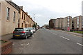
1
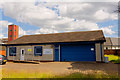
H.M. Coastguard - Ardrossan
Coastguard rescue station
Image: © Ian Rainey
Taken: 7 Jul 2019
0.04 miles
5
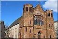
E U Congregational Church, Glasgow Street, Ardrossan
Built 1903
Image: © Leslie Barrie
Taken: 21 Mar 2013
0.09 miles
8
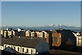
E U Congregational Church viewed from Castle Hill
The Isle of Arran can be seen in the distance.
Image: © Leslie Barrie
Taken: 6 Dec 2008
0.10 miles
10

Eu Congregational Church, Glasgow Street, Ardrossan
Image: © Billy McCrorie
Taken: 14 Apr 2016
0.10 miles