IMAGES TAKEN NEAR TO
Crinan Place, ARDROSSAN, KA22 7PT
Introduction
This page details the photographs taken nearby to Crinan Place, KA22 7PT by members of the Geograph project.
The Geograph project started in 2005 with the aim of publishing, organising and preserving representative images for every square kilometre of Great Britain, Ireland and the Isle of Man.

There are currently over 7.5m images from over14,400 individuals and you can help contribute to the project by visiting https://www.geograph.org.uk
Image Map
Images are licensed for reuse under creativecommons.org/licenses/by-sa/2.0
Notes
- Clicking on the map will re-center to the selected point.
- The higher the marker number, the further away the image location is from the centre of the postcode.
Image Listing (9 Images Found)
Images are licensed for reuse under creativecommons.org/licenses/by-sa/2.0
Image
Details
Distance
3
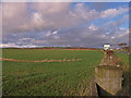
Field and Fence
Looking towards the Haupland moor wind turbines.
Image: © wfmillar
Taken: 26 Nov 2009
0.14 miles
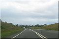
4
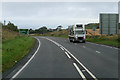
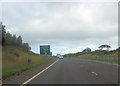
A78 towards Ardrossan
After reaching the northern end of the "Three Towns Bypass", at Chapel Hill, the A78 reverts to single-carriageway.
Image: © David Dixon
Taken: 23 Sep 2019
0.15 miles
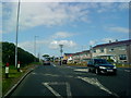
6
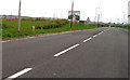
Roundabout Sign
On the B780 Dalry Road at Ardrossan. The roundabout is part of the bypass road.
Image: © Gordon Dowie
Taken: 27 Apr 2010
0.16 miles
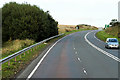
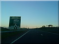
8
Approaching Chapel Hill roundabout
A78 north
Image: © John Firth
Taken: 27 Jul 2012
0.23 miles