IMAGES TAKEN NEAR TO
Dalry Lane, ARDROSSAN, KA22 7LT
Introduction
This page details the photographs taken nearby to Dalry Lane, KA22 7LT by members of the Geograph project.
The Geograph project started in 2005 with the aim of publishing, organising and preserving representative images for every square kilometre of Great Britain, Ireland and the Isle of Man.

There are currently over 7.5m images from over14,400 individuals and you can help contribute to the project by visiting https://www.geograph.org.uk
Image Map
Images are licensed for reuse under creativecommons.org/licenses/by-sa/2.0
Notes
- Clicking on the map will re-center to the selected point.
- The higher the marker number, the further away the image location is from the centre of the postcode.
Image Listing (6 Images Found)
Images are licensed for reuse under creativecommons.org/licenses/by-sa/2.0
Image
Details
Distance
1
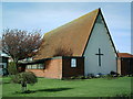
Park Church Ardrossan
The unusually steep roof of Park Church in Ardrossan is easily seen in this photo.
Image: © Ian Rainey
Taken: 5 May 2006
0.08 miles
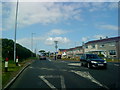
3
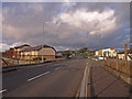
B780, Dalry Road
View from the railway bridge looking towards Chapelhill.
Image: © wfmillar
Taken: 26 Nov 2009
0.20 miles
4
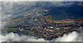
Ardrossan Harbour from the air
Departure point of the ferry to Brodick on the Isle of Arran.
Image: © Thomas Nugent
Taken: 14 Sep 2015
0.23 miles