IMAGES TAKEN NEAR TO
Castle Road, ARDROSSAN, KA22 7BQ
Introduction
This page details the photographs taken nearby to Castle Road, KA22 7BQ by members of the Geograph project.
The Geograph project started in 2005 with the aim of publishing, organising and preserving representative images for every square kilometre of Great Britain, Ireland and the Isle of Man.

There are currently over 7.5m images from over14,400 individuals and you can help contribute to the project by visiting https://www.geograph.org.uk
Image Map
Images are licensed for reuse under creativecommons.org/licenses/by-sa/2.0
Notes
- Clicking on the map will re-center to the selected point.
- The higher the marker number, the further away the image location is from the centre of the postcode.
Image Listing (3 Images Found)
Images are licensed for reuse under creativecommons.org/licenses/by-sa/2.0
Image
Details
Distance
1
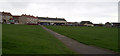
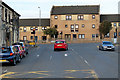
Open Space
Grass area at Queens Drive, Ardrossan. The terrace of flats in the centre have a row of local shops below.
Image: © Gordon Dowie
Taken: 27 Apr 2010
0.13 miles
2
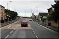
Ardrossan, Eglinton Road
Part of the former route of the A78, now re-designated as A738 following the construction of the "three Towns Bypass" which runs on the northern (inland) side of the three towns Ardrossan, Saltcoats and Stevenston.
Image: © David Dixon
Taken: 23 Sep 2019
0.24 miles