IMAGES TAKEN NEAR TO
Countess Street, SALTCOATS, KA21 9ZA
Introduction
This page details the photographs taken nearby to Countess Street, KA21 9ZA by members of the Geograph project.
The Geograph project started in 2005 with the aim of publishing, organising and preserving representative images for every square kilometre of Great Britain, Ireland and the Isle of Man.

There are currently over 7.5m images from over14,400 individuals and you can help contribute to the project by visiting https://www.geograph.org.uk
Image Map
Images are licensed for reuse under creativecommons.org/licenses/by-sa/2.0
Notes
- Clicking on the map will re-center to the selected point.
- The higher the marker number, the further away the image location is from the centre of the postcode.
Image Listing (374 Images Found)
Images are licensed for reuse under creativecommons.org/licenses/by-sa/2.0
Image
Details
Distance
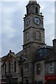
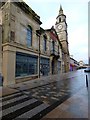
6
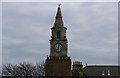
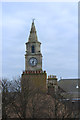
Town Hall Clock, Saltcoats
From Union Street car park.
Image: © Billy McCrorie
Taken: 14 Apr 2016
0.01 miles
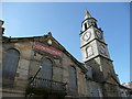
10
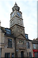
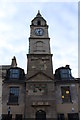
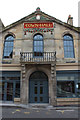
Saltcoats Town Hall
Category B Listed http://portal.historicenvironment.scot/designation/LB40489 , located on Countess Street.
Image: © Thomas Nugent
Taken: 23 Dec 2018
0.01 miles