IMAGES TAKEN NEAR TO
Duguid Drive, SALTCOATS, KA21 6LW
Introduction
This page details the photographs taken nearby to Duguid Drive, KA21 6LW by members of the Geograph project.
The Geograph project started in 2005 with the aim of publishing, organising and preserving representative images for every square kilometre of Great Britain, Ireland and the Isle of Man.

There are currently over 7.5m images from over14,400 individuals and you can help contribute to the project by visiting https://www.geograph.org.uk
Image Map
Images are licensed for reuse under creativecommons.org/licenses/by-sa/2.0
Notes
- Clicking on the map will re-center to the selected point.
- The higher the marker number, the further away the image location is from the centre of the postcode.
Image Listing (7 Images Found)
Images are licensed for reuse under creativecommons.org/licenses/by-sa/2.0
Image
Details
Distance
1
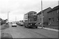
A1 Service bus on Dalry Road, Saltcoats ? 1970
The housing here was still in the course of development, as compared with this 2009 view taken around 200 metres further north https://www.geograph.org.uk/photo/1596231 .
A1 Service was a consortium of a number of local bus operators who ran a network of local services in the Ardrossan/Irvine area as well as a trunk service between Ardrossan and Kilmarnock. OFS968 is a former Edinburgh Corporation Guy Arab IV with Alexander bodywork on local service to the Hayocks area of Stevenston.
This is one of a series of views featuring buses in the 60s, 70s, and 80s. http://www.geograph.org.uk/search.php?i=137652761
Image: © Alan Murray-Rust
Taken: 16 Sep 1970
0.06 miles
2
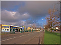
Dalry Road, Saltcoats.
Mainly housing in this area.
Image: © wfmillar
Taken: 26 Nov 2009
0.13 miles
3
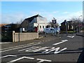
North Parish Church - Saltcoats
The original North Parish church was situated in the town on the site now occupied by Sainsbury's Supermarket in the centre of Saltcoats.
The North Church was erected by subscription in 1836 as a meeting-place for Gaelic-speaking worshippers in the district, and at the Disruption of the Church in 1843, the minister and the larger part of the congregation seceded from the Church of Scotland. Later, services were conducted in Gaelic and English alternately, until in 1873 the North Church was constituted as a Mission Charge under the Parish Church Kirk Session.
In 1906 the North Church became a parish church of the Church of Scotland, the best‑remembered minister being the Rev John R. Spottiswood, whose only charge it was, and who ministered to the congregation for 40 years, from 1899 until 1939.
After the second world war the Church of Scotland recognised a need for a new church to serve the expanding population in the housing areas above Saltcoats High Road, and the North Church was "translated" to a new meeting-place at the Border crossroads where the congregation met at first in a wartime Nissen hut, called St Medan's Hall, then in a hall-church, until the present new North Church was built.
Image: © Raibeart MacAoidh
Taken: 9 Feb 2017
0.14 miles
4
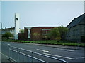
North Parish Church
Note the modern white belltower.
Image: © Ian Rainey
Taken: 9 May 2006
0.14 miles
5
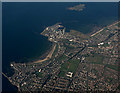
Ardrossan from the air
Ardrossan Harbour is at the top of the photo, Saltcoats Harbour is to the lower left. Horse Isle is visible just off the coast at Ardrossan harbour.
Image: © Thomas Nugent
Taken: 28 Sep 2015
0.15 miles
6
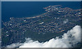
Ardrossan and Saltcoats from the air
Saltcoats on the left, Ardrossan on the right.
Image: © Thomas Nugent
Taken: 20 Mar 2016
0.15 miles
7
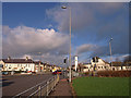
Busy Road Junction, Saltcoats
The A738 High Road crosses the B714 Sharphill Road at these traffic lights. Saltcoats North Parish Church on the right.
Image: © wfmillar
Taken: 26 Nov 2009
0.19 miles