IMAGES TAKEN NEAR TO
Corsankell Wynd, SALTCOATS, KA21 6HZ
Introduction
This page details the photographs taken nearby to Corsankell Wynd, KA21 6HZ by members of the Geograph project.
The Geograph project started in 2005 with the aim of publishing, organising and preserving representative images for every square kilometre of Great Britain, Ireland and the Isle of Man.

There are currently over 7.5m images from over14,400 individuals and you can help contribute to the project by visiting https://www.geograph.org.uk
Image Map
Images are licensed for reuse under creativecommons.org/licenses/by-sa/2.0
Notes
- Clicking on the map will re-center to the selected point.
- The higher the marker number, the further away the image location is from the centre of the postcode.
Image Listing (5 Images Found)
Images are licensed for reuse under creativecommons.org/licenses/by-sa/2.0
Image
Details
Distance
1
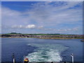
Ardrossan From Arran Ferry
View from the Arran Ferry, shortly after departure.
Image: © Eleanor Graham
Taken: 10 Jul 2005
0.20 miles
3
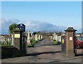
Ardrossan Cemetery Gates
Ardrossan Cemetery, Sorbie Road, Ardrossan, North Ayrshire.
Image: © Raibeart MacAoidh
Taken: 9 Feb 2017
0.24 miles
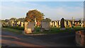
4
Ardrossan Cemetery
The south east corner of the cemetery, looking towards the lodge.
Image: © Thomas Nugent
Taken: 1 Mar 2019
0.25 miles
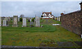
5
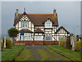
Ardrossan Cemetery lodge
In the south east corner of the cemetery, which is on Sorbie Road.
Image: © Thomas Nugent
Taken: 1 Mar 2019
0.25 miles