IMAGES TAKEN NEAR TO
James Reid Wynd, KA21 6FJ
Introduction
This page details the photographs taken nearby to James Reid Wynd, KA21 6FJ by members of the Geograph project.
The Geograph project started in 2005 with the aim of publishing, organising and preserving representative images for every square kilometre of Great Britain, Ireland and the Isle of Man.

There are currently over 7.5m images from over14,400 individuals and you can help contribute to the project by visiting https://www.geograph.org.uk
Image Map
Images are licensed for reuse under creativecommons.org/licenses/by-sa/2.0
Notes
- Clicking on the map will re-center to the selected point.
- The higher the marker number, the further away the image location is from the centre of the postcode.
Image Listing (11 Images Found)
Images are licensed for reuse under creativecommons.org/licenses/by-sa/2.0
Image
Details
Distance
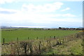
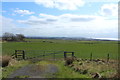
8
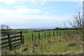
Farmland at Middlepart
Looking out over Saltcoats.
Image: © Billy McCrorie
Taken: 14 Apr 2016
0.22 miles
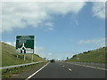
9
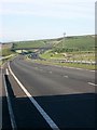
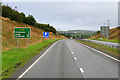
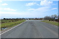
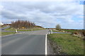
The Three Towns Bypass
This new dual carriageway road was opened in early 2005 and by-passes Stevenson, Saltcoats and Ardrossan. There is an impressive amount of planting on the banks and verges.
Image: © Gordon Brown
Taken: 17 Nov 2005
0.22 miles