IMAGES TAKEN NEAR TO
White Place, SALTCOATS, KA21 6FE
Introduction
This page details the photographs taken nearby to White Place, KA21 6FE by members of the Geograph project.
The Geograph project started in 2005 with the aim of publishing, organising and preserving representative images for every square kilometre of Great Britain, Ireland and the Isle of Man.

There are currently over 7.5m images from over14,400 individuals and you can help contribute to the project by visiting https://www.geograph.org.uk
Image Map
Images are licensed for reuse under creativecommons.org/licenses/by-sa/2.0
Notes
- Clicking on the map will re-center to the selected point.
- The higher the marker number, the further away the image location is from the centre of the postcode.
Image Listing (9 Images Found)
Images are licensed for reuse under creativecommons.org/licenses/by-sa/2.0
Image
Details
Distance
5
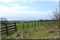
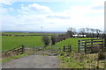
Farmland at Middlepart
Looking out over Saltcoats.
Image: © Billy McCrorie
Taken: 14 Apr 2016
0.19 miles
7
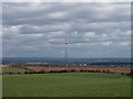
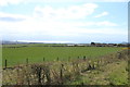
New Wind Turbine, Middlepart Farm
I suspect this new addition to the landscape supplies the near by farm with green electricity. A two-bladed turbine is unusual, as is the lattice tower.
Image: © wfmillar
Taken: 18 Mar 2008
0.23 miles
8
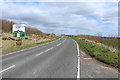
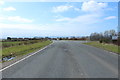
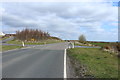
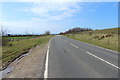
The B714 Approaching Sharphill Roundabout
Image: © Billy McCrorie
Taken: 14 Apr 2016
0.23 miles