IMAGES TAKEN NEAR TO
Adams Avenue, SALTCOATS, KA21 6AP
Introduction
This page details the photographs taken nearby to Adams Avenue, KA21 6AP by members of the Geograph project.
The Geograph project started in 2005 with the aim of publishing, organising and preserving representative images for every square kilometre of Great Britain, Ireland and the Isle of Man.

There are currently over 7.5m images from over14,400 individuals and you can help contribute to the project by visiting https://www.geograph.org.uk
Image Map
Images are licensed for reuse under creativecommons.org/licenses/by-sa/2.0
Notes
- Clicking on the map will re-center to the selected point.
- The higher the marker number, the further away the image location is from the centre of the postcode.
Image Listing (3 Images Found)
Images are licensed for reuse under creativecommons.org/licenses/by-sa/2.0
Image
Details
Distance
1
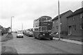
A1 Service bus on Dalry Road, Saltcoats ? 1970
The housing here was still in the course of development, as compared with this 2009 view taken around 200 metres further north https://www.geograph.org.uk/photo/1596231 .
A1 Service was a consortium of a number of local bus operators who ran a network of local services in the Ardrossan/Irvine area as well as a trunk service between Ardrossan and Kilmarnock. OFS968 is a former Edinburgh Corporation Guy Arab IV with Alexander bodywork on local service to the Hayocks area of Stevenston.
This is one of a series of views featuring buses in the 60s, 70s, and 80s. http://www.geograph.org.uk/search.php?i=137652761
Image: © Alan Murray-Rust
Taken: 16 Sep 1970
0.17 miles
2
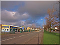
Dalry Road, Saltcoats.
Mainly housing in this area.
Image: © wfmillar
Taken: 26 Nov 2009
0.19 miles
3
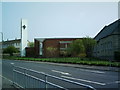
North Parish Church
Note the modern white belltower.
Image: © Ian Rainey
Taken: 9 May 2006
0.24 miles