IMAGES TAKEN NEAR TO
Auchenharvie Road, SALTCOATS, KA21 5RL
Introduction
This page details the photographs taken nearby to Auchenharvie Road, KA21 5RL by members of the Geograph project.
The Geograph project started in 2005 with the aim of publishing, organising and preserving representative images for every square kilometre of Great Britain, Ireland and the Isle of Man.

There are currently over 7.5m images from over14,400 individuals and you can help contribute to the project by visiting https://www.geograph.org.uk
Image Map
Images are licensed for reuse under creativecommons.org/licenses/by-sa/2.0
Notes
- Clicking on the map will re-center to the selected point.
- The higher the marker number, the further away the image location is from the centre of the postcode.
Image Listing (4 Images Found)
Images are licensed for reuse under creativecommons.org/licenses/by-sa/2.0
Image
Details
Distance
1
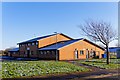
Three Towns Resource Centre - Saltcoats
Ayrshire & Arran NHS Trust Hospital
Image: © Ian Rainey
Taken: 1 Feb 2019
0.18 miles
2
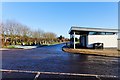
High Road Cemetery - Stevenston
Opened in August 2012 and was needed due to capacity being reached in the Hawkhill Cemetery
Image: © Ian Rainey
Taken: 1 Feb 2019
0.23 miles
3
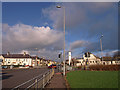
Busy Road Junction, Saltcoats
The A738 High Road crosses the B714 Sharphill Road at these traffic lights. Saltcoats North Parish Church on the right.
Image: © wfmillar
Taken: 26 Nov 2009
0.23 miles
4
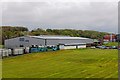
Harvies Swimming Pool, Leisure Centre & Ice Rink - Saltcoats
Started as purely a swimming pool in the early 1970's and expanded into its current facilities. It is rumoured to be closing in the near future despite local petitions to keep it open.
Auchenharvie Academy currently undergoing a facelift with new cladding can be seen at the extreme middle right of the photo with scaffolding all along the back. See https://www.geograph.org.uk/photo/5776318 for the finished front of the academy
Image: © Ian Rainey
Taken: 1 May 2019
0.25 miles