IMAGES TAKEN NEAR TO
Raise Street, SALTCOATS, KA21 5LX
Introduction
This page details the photographs taken nearby to Raise Street, KA21 5LX by members of the Geograph project.
The Geograph project started in 2005 with the aim of publishing, organising and preserving representative images for every square kilometre of Great Britain, Ireland and the Isle of Man.

There are currently over 7.5m images from over14,400 individuals and you can help contribute to the project by visiting https://www.geograph.org.uk
Image Map
Images are licensed for reuse under creativecommons.org/licenses/by-sa/2.0
Notes
- Clicking on the map will re-center to the selected point.
- The higher the marker number, the further away the image location is from the centre of the postcode.
Image Listing (300 Images Found)
Images are licensed for reuse under creativecommons.org/licenses/by-sa/2.0
Image
Details
Distance
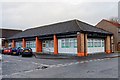
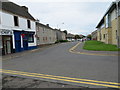
2
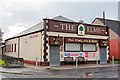
The Elms - Saltcoats
Has karaoke and quiz nights
Image: © Ian Rainey
Taken: 3 Oct 2018
0.01 miles
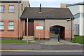
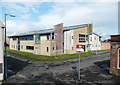
5
North Ayrshire Women's Aid - Saltcoats
Provides a confidential service that gives information, support and temporary accommodation to women and children who have experienced domestic abuse
Image: © Ian Rainey
Taken: 3 Oct 2018
0.02 miles
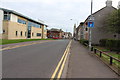
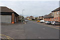
9
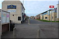
Raise Street in Saltcoats
Looking northward from the Railway Station.
Image: © Peter Wood
Taken: 13 Sep 2016
0.05 miles