IMAGES TAKEN NEAR TO
Raise Street, SALTCOATS, KA21 5JU
Introduction
This page details the photographs taken nearby to Raise Street, KA21 5JU by members of the Geograph project.
The Geograph project started in 2005 with the aim of publishing, organising and preserving representative images for every square kilometre of Great Britain, Ireland and the Isle of Man.

There are currently over 7.5m images from over14,400 individuals and you can help contribute to the project by visiting https://www.geograph.org.uk
Image Map
Images are licensed for reuse under creativecommons.org/licenses/by-sa/2.0
Notes
- Clicking on the map will re-center to the selected point.
- The higher the marker number, the further away the image location is from the centre of the postcode.
Image Listing (336 Images Found)
Images are licensed for reuse under creativecommons.org/licenses/by-sa/2.0
Image
Details
Distance
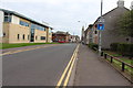
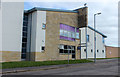
4
Raise Street in Saltcoats
Looking northward from the Railway Station.
Image: © Peter Wood
Taken: 13 Sep 2016
0.02 miles

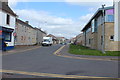
6
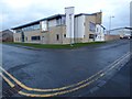
Saltcoats police station
On the corner of Raise Street (left) and Glencairn Street. Opposite Saltcoats railway station.
Image: © Thomas Nugent
Taken: 23 Dec 2018
0.02 miles
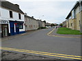
9
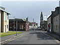
Raise Street.Saltcoats
The police station is on the left, then the station building. The spire in the distance belongs to the Town Hall (see Image).
Image: © Humphrey Bolton
Taken: 28 Apr 2013
0.02 miles
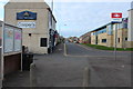
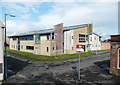
10
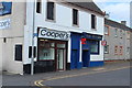
Cooper's and The Victoria, Saltcoats
Bar's on Raise Street.
Image: © Billy McCrorie
Taken: 14 Apr 2016
0.02 miles