IMAGES TAKEN NEAR TO
Canal Street, SALTCOATS, KA21 5HY
Introduction
This page details the photographs taken nearby to Canal Street, KA21 5HY by members of the Geograph project.
The Geograph project started in 2005 with the aim of publishing, organising and preserving representative images for every square kilometre of Great Britain, Ireland and the Isle of Man.

There are currently over 7.5m images from over14,400 individuals and you can help contribute to the project by visiting https://www.geograph.org.uk
Image Map
Images are licensed for reuse under creativecommons.org/licenses/by-sa/2.0
Notes
- Clicking on the map will re-center to the selected point.
- The higher the marker number, the further away the image location is from the centre of the postcode.
Image Listing (184 Images Found)
Images are licensed for reuse under creativecommons.org/licenses/by-sa/2.0
Image
Details
Distance
1
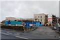
New Flats - Saltcoats
Flats under construction on Canal Street
Image: © Ian Rainey
Taken: 3 Oct 2018
0.02 miles
2
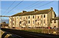
Tenement Block, Saltcoats, North Ayrshire
The rear of the tenement block situated on Canal Street.
Image: © Mark S
Taken: 13 Jan 2024
0.02 miles
3
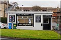
Miss Perfection - Saltcoats
Beauty treatments. Manicures & pedicures, Tanning, Waxing, Massage ...
Image: © Ian Rainey
Taken: 3 Oct 2018
0.02 miles
4

Salon L&M - Saltcoats
Hair & beauty salon
Image: © Ian Rainey
Taken: 3 Oct 2018
0.03 miles
5
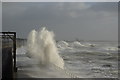
Storm hits Saltcoats
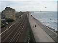
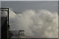
East Shore Saltcoats viewed from the pedestrian footbridge, taken a short while after high tide and during an all too brief sunny interlude. The media reported this as the most severe storm to hit this part of the country in a decade. Due to the close proximity of the railway line to the sea wall, services were suspended along this stretch; Scotrail providing a replacement bus service calling at stations between Kilwinning and Largs. On occasions of stormy weather, this location appears frequently on tv screens across Scotland and occasionally UK wide.
Image: © Leslie Barrie
Taken: 8 Dec 2011
0.03 miles
7
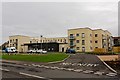
Kyleshill Court & David White Community Hub - Saltcoats
Recently completed new state of the art sheltered housing which replaced the old Canal Court and David White Centre. See https://www.geograph.org.uk/photo/5928717 for buildings under construction
Image: © Ian Rainey
Taken: 1 May 2019
0.04 miles
8
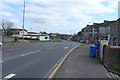
Seaview Road, Saltcoats, North Ayrshire
Looking east along Seaview Road.
Image: © Mark S
Taken: 13 Jan 2024
0.04 miles
10
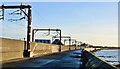
Storm hits Saltcoats
East Shore Saltcoats viewed from the pedestrian footbridge, taken a short while after high tide and during an all too brief sunny interlude. The media reported this as the most severe storm to hit this part of the country in a decade. Due to the close proximity of the railway line to the sea wall, services were suspended along this stretch; Scotrail providing a replacement bus service calling at stations between Kilwinning and Largs. On occasions of stormy weather, this location appears frequently on tv screens across Scotland and occasionally UK wide.
Image: © Leslie Barrie
Taken: 8 Dec 2011
0.04 miles