IMAGES TAKEN NEAR TO
Franklin Road, SALTCOATS, KA21 5AT
Introduction
This page details the photographs taken nearby to Franklin Road, KA21 5AT by members of the Geograph project.
The Geograph project started in 2005 with the aim of publishing, organising and preserving representative images for every square kilometre of Great Britain, Ireland and the Isle of Man.

There are currently over 7.5m images from over14,400 individuals and you can help contribute to the project by visiting https://www.geograph.org.uk
Image Map
Images are licensed for reuse under creativecommons.org/licenses/by-sa/2.0
Notes
- Clicking on the map will re-center to the selected point.
- The higher the marker number, the further away the image location is from the centre of the postcode.
Image Listing (57 Images Found)
Images are licensed for reuse under creativecommons.org/licenses/by-sa/2.0
Image
Details
Distance
1
Caledonia Road, Saltcoats, North Ayrshire
Elegant villas on Caledonia Road.
Image: © Mark S
Taken: 3 Feb 2024
0.06 miles
2
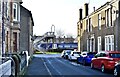
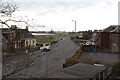
Stanley Place, Saltcoats, North Ayrshire
Looking towards the railway line.
Image: © Mark S
Taken: 3 Feb 2024
0.12 miles
3
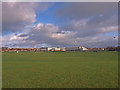
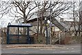
Ardrossan Academy
View across the playing fields to the new academy.
Image: © wfmillar
Taken: 26 Nov 2009
0.13 miles
4
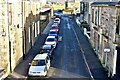
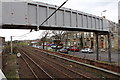
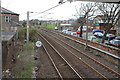
Stanley Place, Saltcoats, North Ayrshire
As seen from the railway footbridge.
Image: © Mark S
Taken: 3 Feb 2024
0.13 miles
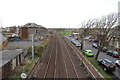
7
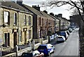
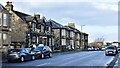
Stanley Road, Saltcoats, North Ayrshire
Properties on Stanley Road, as seen from the railway footbridge.
Image: © Mark S
Taken: 3 Feb 2024
0.13 miles