IMAGES TAKEN NEAR TO
Glentruim View, KILMARNOCK, KA2 0LL
Introduction
This page details the photographs taken nearby to Glentruim View, KA2 0LL by members of the Geograph project.
The Geograph project started in 2005 with the aim of publishing, organising and preserving representative images for every square kilometre of Great Britain, Ireland and the Isle of Man.

There are currently over 7.5m images from over14,400 individuals and you can help contribute to the project by visiting https://www.geograph.org.uk
Image Map
Images are licensed for reuse under creativecommons.org/licenses/by-sa/2.0
Notes
- Clicking on the map will re-center to the selected point.
- The higher the marker number, the further away the image location is from the centre of the postcode.
Image Listing (18 Images Found)
Images are licensed for reuse under creativecommons.org/licenses/by-sa/2.0
Image
Details
Distance
1
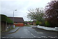
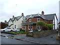
Smillie Place, Kilmarnock
South of Dundonald Road.
Image: © JThomas
Taken: 21 May 2021
0.05 miles
2
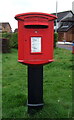
Elizabethan postbox on Dundonald Road, Kilmarnock
Postbox No. KA1 204.
See Image] for context.
Image: © JThomas
Taken: 21 May 2021
0.06 miles
3
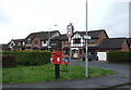
Houses on Glen Trool Walk, Kilmarnock
Showing position of Postbox No. KA1 204.
See Image] for postbox.
Image: © JThomas
Taken: 21 May 2021
0.07 miles
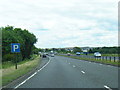
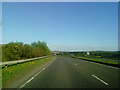
9
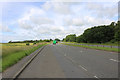
The A71 to Irvine
Passing Kilmarnock.
Image: © Billy McCrorie
Taken: 7 Jul 2020
0.18 miles
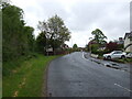
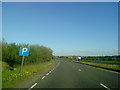
10
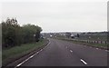
Lay by on A71 just east of Dundonald Road
Dundonald Road passes beneath the A71 here
Image: © John Firth
Taken: 19 May 2013
0.19 miles