IMAGES TAKEN NEAR TO
Annandale Crescent, KILMARNOCK, KA2 0EP
Introduction
This page details the photographs taken nearby to Annandale Crescent, KA2 0EP by members of the Geograph project.
The Geograph project started in 2005 with the aim of publishing, organising and preserving representative images for every square kilometre of Great Britain, Ireland and the Isle of Man.

There are currently over 7.5m images from over14,400 individuals and you can help contribute to the project by visiting https://www.geograph.org.uk
Image Map
Images are licensed for reuse under creativecommons.org/licenses/by-sa/2.0
Notes
- Clicking on the map will re-center to the selected point.
- The higher the marker number, the further away the image location is from the centre of the postcode.
Image Listing (83 Images Found)
Images are licensed for reuse under creativecommons.org/licenses/by-sa/2.0
Image
Details
Distance
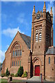
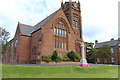
1
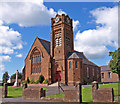
Crosshouse Parish Church
www.crosshouseparishchurch.org.uk
Image: © wfmillar
Taken: 17 Aug 2010
0.04 miles
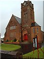
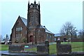
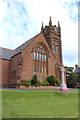
5
Crosshouse Parish Church
Category C-listed. Built 1882. Architects Bruce Sturrock & Co.
Image: © Leslie Barrie
Taken: 14 Sep 2013
0.07 miles
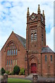
9
Crosshouse Parish Church
And War Memorial.
Image: © Billy McCrorie
Taken: 15 Sep 2017
0.08 miles
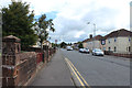
10
Crosshouse Parish Church
And War Memorial.
Image: © Billy McCrorie
Taken: 15 Sep 2017
0.08 miles