IMAGES TAKEN NEAR TO
Pollock-Morris Drive, KILMARNOCK, KA2 0EJ
Introduction
This page details the photographs taken nearby to Pollock-Morris Drive, KA2 0EJ by members of the Geograph project.
The Geograph project started in 2005 with the aim of publishing, organising and preserving representative images for every square kilometre of Great Britain, Ireland and the Isle of Man.

There are currently over 7.5m images from over14,400 individuals and you can help contribute to the project by visiting https://www.geograph.org.uk
Image Map
Images are licensed for reuse under creativecommons.org/licenses/by-sa/2.0
Notes
- Clicking on the map will re-center to the selected point.
- The higher the marker number, the further away the image location is from the centre of the postcode.
Image Listing (6 Images Found)
Images are licensed for reuse under creativecommons.org/licenses/by-sa/2.0
Image
Details
Distance
3
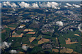
Springside and Dreghorn from the air
The paper mill at Irvine can be seen on the left.
Image: © Thomas Nugent
Taken: 31 Aug 2015
0.22 miles
4
River Irvine
Near Cockhill. After a cold snap further up stream the river was frozen about half way across.
Image: © wfmillar
Taken: 9 Feb 2007
0.23 miles
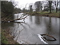
5
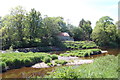
River Irvine
River Irvine, weir and old mill building; the remains of a water wheel can be seen.
Image: © Scott
Taken: 28 May 2012
0.24 miles
