IMAGES TAKEN NEAR TO
Southhook Road, KILMARNOCK, KA2 0EF
Introduction
This page details the photographs taken nearby to Southhook Road, KA2 0EF by members of the Geograph project.
The Geograph project started in 2005 with the aim of publishing, organising and preserving representative images for every square kilometre of Great Britain, Ireland and the Isle of Man.

There are currently over 7.5m images from over14,400 individuals and you can help contribute to the project by visiting https://www.geograph.org.uk
Image Map
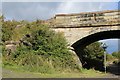
Images are licensed for reuse under creativecommons.org/licenses/by-sa/2.0
Notes
- Clicking on the map will re-center to the selected point.
- The higher the marker number, the further away the image location is from the centre of the postcode.
Image Listing (5 Images Found)
Images are licensed for reuse under creativecommons.org/licenses/by-sa/2.0
Image
Details
Distance
3
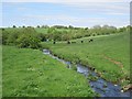
Garrier Burn
Flowing through pasture near Knockentiber.
Image: © Richard Webb
Taken: 21 May 2013
0.09 miles
5
National Cycle Network Route 73 between Springside & Knockentiber
Image: © Leslie Barrie
Taken: 14 Sep 2013
0.25 miles