IMAGES TAKEN NEAR TO
Hemphill View, KILMARNOCK, KA2 0DF
Introduction
This page details the photographs taken nearby to Hemphill View, KA2 0DF by members of the Geograph project.
The Geograph project started in 2005 with the aim of publishing, organising and preserving representative images for every square kilometre of Great Britain, Ireland and the Isle of Man.

There are currently over 7.5m images from over14,400 individuals and you can help contribute to the project by visiting https://www.geograph.org.uk
Image Map
Images are licensed for reuse under creativecommons.org/licenses/by-sa/2.0
Notes
- Clicking on the map will re-center to the selected point.
- The higher the marker number, the further away the image location is from the centre of the postcode.
Image Listing (14 Images Found)
Images are licensed for reuse under creativecommons.org/licenses/by-sa/2.0
Image
Details
Distance
4
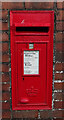
Elizabethan postbox on Kilmaurs Road, Knockentiber
Postbox No. KA2 57.
Image: © JThomas
Taken: 23 May 2021
0.10 miles
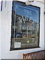
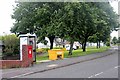
8
The Tiber Tavern, Knockentiber
On the B751.
Image: © JThomas
Taken: 23 May 2021
0.11 miles
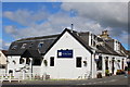
9
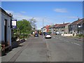
Kilmaurs Road, Knockantiber
On the left is the Tiber Tavern which also contains a shop, the Tiber Store.
Image: © Richard Webb
Taken: 21 May 2013
0.11 miles
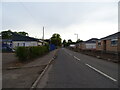
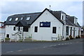
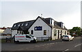
10
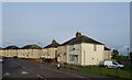
Greenhill Terrace
Houses on the B751, Knockentiber.
Image: © JThomas
Taken: 23 May 2021
0.12 miles