IMAGES TAKEN NEAR TO
St. Johns Place, STEVENSTON, KA20 4JL
Introduction
This page details the photographs taken nearby to St. Johns Place, KA20 4JL by members of the Geograph project.
The Geograph project started in 2005 with the aim of publishing, organising and preserving representative images for every square kilometre of Great Britain, Ireland and the Isle of Man.

There are currently over 7.5m images from over14,400 individuals and you can help contribute to the project by visiting https://www.geograph.org.uk
Image Map
Images are licensed for reuse under creativecommons.org/licenses/by-sa/2.0
Notes
- Clicking on the map will re-center to the selected point.
- The higher the marker number, the further away the image location is from the centre of the postcode.
Image Listing (27 Images Found)
Images are licensed for reuse under creativecommons.org/licenses/by-sa/2.0
Image
Details
Distance

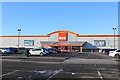
2

B&Q at Hawkhill Retail Park, Stevenston
Image: © Billy McCrorie
Taken: 2 Feb 2019
0.12 miles
3
B&Q at Hawkhill Retail Park, Stevenston
Image: © Billy McCrorie
Taken: 2 Feb 2019
0.13 miles
4

b&m at Hawkhill Retail Park, Stevenston
Image: © Billy McCrorie
Taken: 2 Feb 2019
0.17 miles
5
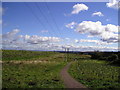
Footpath
Footpath to join the A738 to Kilwinning. The newly planted trees, landscaping on the left of the picture hide the new A78 bypass route.
Image: © Chris Court
Taken: 13 Oct 2005
0.18 miles

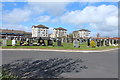
7

A retail park in Stevenston
Shielded from the A78 by a shelter belt.
Image: © Alan Reid
Taken: 8 Feb 2017
0.18 miles
9

McDonald's at Hawkhill Retail Park, Stevenston
Image: © Billy McCrorie
Taken: 2 Feb 2019
0.19 miles
