IMAGES TAKEN NEAR TO
Sommerville Drive, STEVENSTON, KA20 3PA
Introduction
This page details the photographs taken nearby to Sommerville Drive, KA20 3PA by members of the Geograph project.
The Geograph project started in 2005 with the aim of publishing, organising and preserving representative images for every square kilometre of Great Britain, Ireland and the Isle of Man.

There are currently over 7.5m images from over14,400 individuals and you can help contribute to the project by visiting https://www.geograph.org.uk
Image Map
Images are licensed for reuse under creativecommons.org/licenses/by-sa/2.0
Notes
- Clicking on the map will re-center to the selected point.
- The higher the marker number, the further away the image location is from the centre of the postcode.
Image Listing (25 Images Found)
Images are licensed for reuse under creativecommons.org/licenses/by-sa/2.0
Image
Details
Distance
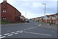
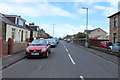
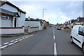
5
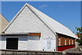
The United Free Church of Scotland, Ardeer
Known as 'The Tin Kirk'
Image: © Leslie Barrie
Taken: 8 Jun 2013
0.11 miles
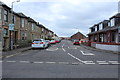
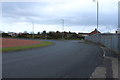
6
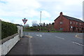
Approaching Lundholm Road, Stevenston
Image: © Billy McCrorie
Taken: 2 May 2016
0.11 miles
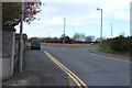
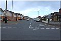
10
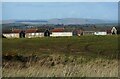
Houses on Trelawny Terrace
The edge of Stevenston. In the far distance are turbines of the Ardrossan Wind Farm.
Image: © Richard Sutcliffe
Taken: 18 Mar 2022
0.16 miles