IMAGES TAKEN NEAR TO
Lundholm Road, STEVENSTON, KA20 3LJ
Introduction
This page details the photographs taken nearby to Lundholm Road, KA20 3LJ by members of the Geograph project.
The Geograph project started in 2005 with the aim of publishing, organising and preserving representative images for every square kilometre of Great Britain, Ireland and the Isle of Man.

There are currently over 7.5m images from over14,400 individuals and you can help contribute to the project by visiting https://www.geograph.org.uk
Image Map
Images are licensed for reuse under creativecommons.org/licenses/by-sa/2.0
Notes
- Clicking on the map will re-center to the selected point.
- The higher the marker number, the further away the image location is from the centre of the postcode.
Image Listing (3 Images Found)
Images are licensed for reuse under creativecommons.org/licenses/by-sa/2.0
Image
Details
Distance
1
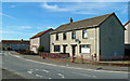
Golf Avenue, Stevenston
Council housing area located at the end of Lundholm Road.
Image: © Mary and Angus Hogg
Taken: 20 Mar 2018
0.02 miles
2
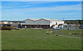
Industrial Site at Stevenston
This view shows Scott Engineering, located on First Avenue. These modern units have replaced the former ICI explosives factory which occupied the whole site.
Image: © Mary and Angus Hogg
Taken: 20 Mar 2018
0.11 miles
3
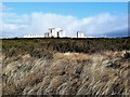
B P I Visqueen Industrial-Ardeer
Looking towards BPI Visqueen Industrial-Ardeer from the dunes.
Ardeer was once an island with a sea channel running along to exit in the vicinity of Auchenharvie Academy. By the late 17th century the island had become a peninsula due to extreme sand movements which may have also choked the sea channel that had made Ardeer an island.
Image: © Raibeart MacAoidh
Taken: 29 Jan 2018
0.25 miles