IMAGES TAKEN NEAR TO
Shore Road, STEVENSTON, KA20 3LA
Introduction
This page details the photographs taken nearby to Shore Road, KA20 3LA by members of the Geograph project.
The Geograph project started in 2005 with the aim of publishing, organising and preserving representative images for every square kilometre of Great Britain, Ireland and the Isle of Man.

There are currently over 7.5m images from over14,400 individuals and you can help contribute to the project by visiting https://www.geograph.org.uk
Image Map
Images are licensed for reuse under creativecommons.org/licenses/by-sa/2.0
Notes
- Clicking on the map will re-center to the selected point.
- The higher the marker number, the further away the image location is from the centre of the postcode.
Image Listing (66 Images Found)
Images are licensed for reuse under creativecommons.org/licenses/by-sa/2.0
Image
Details
Distance
3
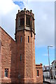
Ardeer Parish Church Tower, Stevenston
Image: © Billy McCrorie
Taken: 2 May 2016
0.02 miles
6
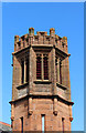
Ardeer Parish Church Tower, Stevenston
Date on the Tower is 1894.
Image: © Billy McCrorie
Taken: 2 May 2016
0.03 miles
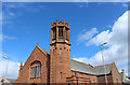
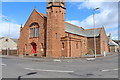
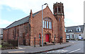
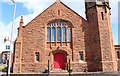
9

Ardeer Parish Church, Stevenston
Built 1894-5 from Ballochmyle sandstone and opened 14 June 1895. Architect Hippolyte Blanc.
Image: © Leslie Barrie
Taken: 21 Apr 2013
0.03 miles
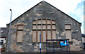
10
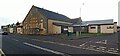
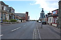
Caley Youth Centre, Stevenston
On Shore Road.
Image: © Thomas Nugent
Taken: 8 Nov 2023
0.03 miles