IMAGES TAKEN NEAR TO
High Road, STEVENSTON, KA20 3DX
Introduction
This page details the photographs taken nearby to High Road, KA20 3DX by members of the Geograph project.
The Geograph project started in 2005 with the aim of publishing, organising and preserving representative images for every square kilometre of Great Britain, Ireland and the Isle of Man.

There are currently over 7.5m images from over14,400 individuals and you can help contribute to the project by visiting https://www.geograph.org.uk
Image Map
Images are licensed for reuse under creativecommons.org/licenses/by-sa/2.0
Notes
- Clicking on the map will re-center to the selected point.
- The higher the marker number, the further away the image location is from the centre of the postcode.
Image Listing (12 Images Found)
Images are licensed for reuse under creativecommons.org/licenses/by-sa/2.0
Image
Details
Distance
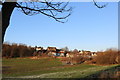
1

High Road Cemetery - Stevenston
Opened in August 2012 and was needed due to capacity being reached in the Hawkhill Cemetery
Image: © Ian Rainey
Taken: 1 Feb 2019
0.15 miles
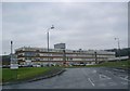
4

Three Towns Resource Centre - Saltcoats
Ayrshire & Arran NHS Trust Hospital
Image: © Ian Rainey
Taken: 1 Feb 2019
0.20 miles
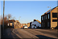


8

Entrance to Lidl Car Park, Stevenston
Image: © Billy McCrorie
Taken: 2 Feb 2019
0.22 miles
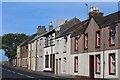
10
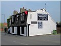
McGlone's Bar - Stevenston
Get's a five star rating on trip adviser
Image: © Ian Rainey
Taken: 24 Apr 2019
0.24 miles