IMAGES TAKEN NEAR TO
Grange Court, STEVENSTON, KA20 3DW
Introduction
This page details the photographs taken nearby to Grange Court, KA20 3DW by members of the Geograph project.
The Geograph project started in 2005 with the aim of publishing, organising and preserving representative images for every square kilometre of Great Britain, Ireland and the Isle of Man.

There are currently over 7.5m images from over14,400 individuals and you can help contribute to the project by visiting https://www.geograph.org.uk
Image Map
Images are licensed for reuse under creativecommons.org/licenses/by-sa/2.0
Notes
- Clicking on the map will re-center to the selected point.
- The higher the marker number, the further away the image location is from the centre of the postcode.
Image Listing (71 Images Found)
Images are licensed for reuse under creativecommons.org/licenses/by-sa/2.0
Image
Details
Distance
1
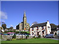
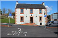
Saints and Sinners
Church of Scotland High Kirk, and the Champion Shell Inn, Stevenston.
Image: © Chris Court
Taken: 13 Oct 2005
0.03 miles
9
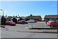
Schoolwell Street, Car Park, Stevenston
Image: © Billy McCrorie
Taken: 2 May 2016
0.07 miles
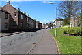
10
Exit from Schoolwell Street Car Park
Looking at the Champion Shell Inn. Make sure you turn left.
Image: © Billy McCrorie
Taken: 2 May 2016
0.07 miles