IMAGES TAKEN NEAR TO
KA19 9AF
Introduction
This page details the photographs taken nearby to KA19 9AF by members of the Geograph project.
The Geograph project started in 2005 with the aim of publishing, organising and preserving representative images for every square kilometre of Great Britain, Ireland and the Isle of Man.

There are currently over 7.5m images from over14,400 individuals and you can help contribute to the project by visiting https://www.geograph.org.uk
Image Map
Images are licensed for reuse under creativecommons.org/licenses/by-sa/2.0
Notes
- Clicking on the map will re-center to the selected point.
- The higher the marker number, the further away the image location is from the centre of the postcode.
Image Listing (509 Images Found)
Images are licensed for reuse under creativecommons.org/licenses/by-sa/2.0
Image
Details
Distance
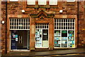
1
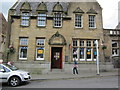
Maybole Post Office
Post office situated on the High St.
Image: © Billy McCrorie
Taken: 25 Aug 2011
0.00 miles
2
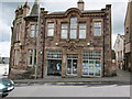
Maybole Library
At the junction with the High St and St Cuthbert's Road.
Image: © Billy McCrorie
Taken: 25 Aug 2011
0.00 miles
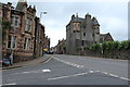
3
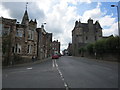
High Street
Looking up the High Street from the junction with St Cuthbert's Road. Maybole Castle is on the right.
Image: © Billy McCrorie
Taken: 25 Aug 2011
0.01 miles
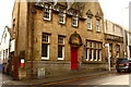
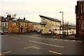
6
High Street, Maybole
Showing Maybole Castle.
Image: © Billy McCrorie
Taken: 22 Aug 2017
0.01 miles
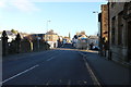
8
Junction of High Street and St Cuthbert's Road
Image: © Billy McCrorie
Taken: 14 Nov 2016
0.01 miles
10
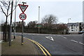
St Cuthbert's Road at Junction with the High Street, Maybole
Image: © Billy McCrorie
Taken: 28 Jan 2016
0.02 miles