IMAGES TAKEN NEAR TO
MAYBOLE, KA19 8LR
Introduction
This page details the photographs taken nearby to KA19 8LR by members of the Geograph project.
The Geograph project started in 2005 with the aim of publishing, organising and preserving representative images for every square kilometre of Great Britain, Ireland and the Isle of Man.

There are currently over 7.5m images from over14,400 individuals and you can help contribute to the project by visiting https://www.geograph.org.uk
Image Map
Images are licensed for reuse under creativecommons.org/licenses/by-sa/2.0
Notes
- Clicking on the map will re-center to the selected point.
- The higher the marker number, the further away the image location is from the centre of the postcode.
Image Listing (12 Images Found)
Images are licensed for reuse under creativecommons.org/licenses/by-sa/2.0
Image
Details
Distance
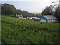
1

Old Milestone by Craigfin Woods, Maybole parish
Stone post by the UC road, in parish of Maybole (Carrick District), Craigfin Woods, opposite Little Craigfin.
Inscription reads:-
: MAYBOLE / 3 : : GIRVAN / 20 :
Surveyed
Milestone Society National ID: AYS_MBGVN03
Image: © Milestone Society
Taken: Unknown
0.03 miles
3
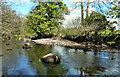
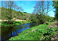
At the Water of Girvan
The 2020 Coronavirus restrictions made me look more closely at my immediate local area. I had never walked on this side of the river before between Knockroon and Carsloe. I feel very lucky to live in such a lovely area and to have the health and fitness to enjoy it.
Image: © Mary and Angus Hogg
Taken: 26 Apr 2020
0.11 miles
4
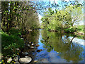
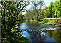
Beside the Water of Girvan
Looking upstream on a lovely late-April afternoon while out for some daily exercise during the 2020 Coronavirus restrictions.
Image: © Mary and Angus Hogg
Taken: 26 Apr 2020
0.14 miles
5
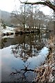
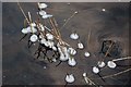
Frosty Scene
Reflections on the Water of Girvan on a chilly December afternoon. This was the third consecutive day when the frost didn't thaw.
Image: © Mary and Angus Hogg
Taken: 30 Dec 2008
0.16 miles
6
Approaching the end of the riverside path
The path on this part of the north bank of the Water of Girvan comes to an end where the fields of Knockroon Farm begin. Although it's possible to continue, walkers have to give way to livestock in the fields. For a 2007 view, see Image
Image: © Mary and Angus Hogg
Taken: 18 May 2021
0.20 miles
7
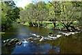
Stones across the Water of Girvan
The river is split up into pools for the benefit of fish and anglers. They also make lovely views of this South Ayrshire river.
Image: © Mary and Angus Hogg
Taken: 18 May 2021
0.22 miles
8
Walking by the Water of Girvan
A downstream mid-May view, taken a year after the 2020 lockdown view seen from the other bank Image
Image: © Mary and Angus Hogg
Taken: 18 May 2021
0.22 miles
9
Ice Formation
Small pieces of ice were forming around the grass stems at the edge of the Water of Girvan. Viewed on a chilly late December afternoon.
Image: © Mary and Angus Hogg
Taken: 30 Dec 2008
0.23 miles
10
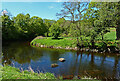
A big bend on the Water of Girvan
Looking downstream from the Knockroon side of the river on a lovely mid-May morning.
Image: © Mary and Angus Hogg
Taken: 18 May 2021
0.23 miles