IMAGES TAKEN NEAR TO
Croy, MAYBOLE, KA19 8JS
Introduction
This page details the photographs taken nearby to KA19 8JS by members of the Geograph project.
The Geograph project started in 2005 with the aim of publishing, organising and preserving representative images for every square kilometre of Great Britain, Ireland and the Isle of Man.

There are currently over 7.5m images from over14,400 individuals and you can help contribute to the project by visiting https://www.geograph.org.uk
Image Map
Images are licensed for reuse under creativecommons.org/licenses/by-sa/2.0
Notes
- Clicking on the map will re-center to the selected point.
- The higher the marker number, the further away the image location is from the centre of the postcode.
Image Listing (53 Images Found)
Images are licensed for reuse under creativecommons.org/licenses/by-sa/2.0
Image
Details
Distance
1
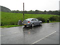
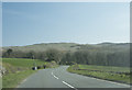
Electric Brae, South Ayrshire
Didn't believe it until we tried it. Car facing downhill came to a stop and it started to roll backwards! Situated on the coastal road from Girvan to Ayr.
Image: © Josie Campbell
Taken: 15 Sep 2008
0.11 miles
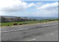
2
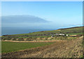
Knoweside
The photograph includes one of South Ayrshire's many caravan sites. This one overlooks Culzean Bay, with stunning views over the Firth of Clyde. For an early-summer view, see Image
Image: © Mary and Angus Hogg
Taken: 16 Jan 2007
0.12 miles
3
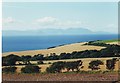
View over fields to Arran from Knowside, Ayrshire
Image: © nick macneill
Taken: 18 Aug 2002
0.13 miles
4
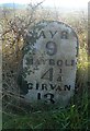
Forgotten Milestone
This old milestone, showing distances in quarter miles, is in danger of becoming overgrown.
Image: © Mary and Angus Hogg
Taken: 18 Nov 2007
0.13 miles
5
Looking across the Electric Brae
At this point, the road on the right hand side is lower than the left! It was believed that electric or magnetic attraction within the brae caused this illusion.
Image: © Ann Cook
Taken: 1 May 2013
0.13 miles
6
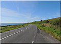
Croy Brae (Electric Brae)
Optical illusion; you think you're going uphill when you're actually going downhill on the A719 to Ayr.
Image: © Billy McCrorie
Taken: 8 Aug 2012
0.13 miles
7
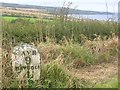
Old Milestone by the A719, Electric Bray, Maybole Parish
By the A719, in parish of Maybole (Carrick District), Electric Bray, 10m East of 'Bend' sign.
Inscription reads:- : AYR / 9 / MAYBOLE / 4¼ / GIRVAN / 13 :
Surveyed
Milestone Society National ID: AYS_AYTB09
Image: © Milestone Society
Taken: Unknown
0.14 miles
8
Croy Brae (Electric Brae)
An optical illusion. This stretch of road is actually heading uphill.
Image: © Leslie Barrie
Taken: 10 Dec 2008
0.14 miles
9
Electric Brae
Electric Brae or Croy Brae is a road with an optical illusion. If you stop the car and take the hand brake off the car appears to roll up hill!
Image: © Malcolm Neal
Taken: 8 Apr 2019
0.14 miles
10
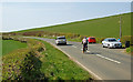
Not Going Up
On the Electric Brae, there’s a slope of 1 in 86 falling from the bend in the road to the west towards Craigencroy Glen to the east. The configuration of the land on both sides of the road make it look like the slope goes the other way. The cyclist in this shot free-wheeled uphill.
Image: © Mary and Angus Hogg
Taken: 20 Apr 2014
0.14 miles