IMAGES TAKEN NEAR TO
Croy, MAYBOLE, KA19 8JR
Introduction
This page details the photographs taken nearby to KA19 8JR by members of the Geograph project.
The Geograph project started in 2005 with the aim of publishing, organising and preserving representative images for every square kilometre of Great Britain, Ireland and the Isle of Man.

There are currently over 7.5m images from over14,400 individuals and you can help contribute to the project by visiting https://www.geograph.org.uk
Image Map
Images are licensed for reuse under creativecommons.org/licenses/by-sa/2.0
Notes
- Clicking on the map will re-center to the selected point.
- The higher the marker number, the further away the image location is from the centre of the postcode.
Image Listing (43 Images Found)
Images are licensed for reuse under creativecommons.org/licenses/by-sa/2.0
Image
Details
Distance
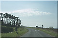
2
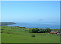
From Knoweside Farm
Looking across the Firth of Clyde from Knoweside Farm's barley field on a beautiful April afternoon. The haze had just cleared sufficiently to get a good view of Ailsa Craig.
Image: © Mary and Angus Hogg
Taken: 26 Apr 2007
0.11 miles
3
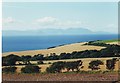
View over fields to Arran from Knowside, Ayrshire
Image: © nick macneill
Taken: 18 Aug 2002
0.12 miles
5
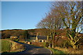
Approaching Knowlside
Knowlside is just a couple of houses opposite the turn off to the minor road leading to a holiday park and Croy House.
Image: © Malcolm Neal
Taken: 8 Apr 2019
0.12 miles
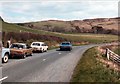
7
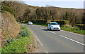
Coming Up?
On the Electric Brae, there’s a slope of 1 in 86 falling from the bend in the road to the west towards Craigencroy Glen to the east. The configuration of the land on both sides of the road make it look like the slope goes the other way. These two cars are really going downhill.
Image: © Mary and Angus Hogg
Taken: 20 Apr 2014
0.13 miles
8
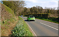
Not Going Down
On the Electric Brae, there’s a slope of 1 in 86 falling from the bend in the road to the west towards Craigencroy Glen to the east. The configuration of the land on both sides of the road make it look like the slope goes the other way. The best effect is obtained by travelling from west to east. The green car is really going uphill.
Image: © Mary and Angus Hogg
Taken: 20 Apr 2014
0.13 miles
9
The Electric Brae
Looking down the Electric Brae. Or is it up? An optical illusion caused by the surrounding landscape makes it look as if the road is descending when it's actually ascending. Or is it the other way round? Photographed in the spring of 1984, a fine selection of vintage late 70s/early 80s tin is present - Mk 4 Ford Cortina, Morris Marina Estate and a Mk2 Ford Granada.
Image: © Robert Struthers
Taken: Unknown
0.14 miles
10
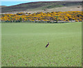
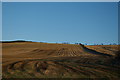
Brown Hare In The Barley
While making my way up the field edge, I disturbed this Brown Hare in the barley. It watched me for a while, then loped off to a more camouflaged location.
Image: © Mary and Angus Hogg
Taken: 26 Apr 2007
0.15 miles