IMAGES TAKEN NEAR TO
Kirkoswald, MAYBOLE, KA19 8JH
Introduction
This page details the photographs taken nearby to KA19 8JH by members of the Geograph project.
The Geograph project started in 2005 with the aim of publishing, organising and preserving representative images for every square kilometre of Great Britain, Ireland and the Isle of Man.

There are currently over 7.5m images from over14,400 individuals and you can help contribute to the project by visiting https://www.geograph.org.uk
Image Map
Images are licensed for reuse under creativecommons.org/licenses/by-sa/2.0
Notes
- Clicking on the map will re-center to the selected point.
- The higher the marker number, the further away the image location is from the centre of the postcode.
Image Listing (9 Images Found)
Images are licensed for reuse under creativecommons.org/licenses/by-sa/2.0
Image
Details
Distance
2
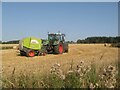
Straw baling
Farm work never stops in fine weather! A tractor and baler working at Thomaston.
Image: © Jonathan Wilkins
Taken: 8 Sep 2023
0.06 miles
3

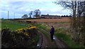
Track approaching Thomaston
A most amenable track approaching the farm complex at Thomaston.
Image: © Jonathan Wilkins
Taken: 8 Sep 2023
0.11 miles
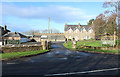
4
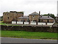
Kennels with the remains of Thomaston Castle
Viewed from the east from the road.
Image: © Peter Wood
Taken: 23 Sep 2013
0.23 miles