IMAGES TAKEN NEAR TO
Merkland Terrace, MAYBOLE, KA19 8JG
Introduction
This page details the photographs taken nearby to Merkland Terrace, KA19 8JG by members of the Geograph project.
The Geograph project started in 2005 with the aim of publishing, organising and preserving representative images for every square kilometre of Great Britain, Ireland and the Isle of Man.

There are currently over 7.5m images from over14,400 individuals and you can help contribute to the project by visiting https://www.geograph.org.uk
Image Map
Images are licensed for reuse under creativecommons.org/licenses/by-sa/2.0
Notes
- Clicking on the map will re-center to the selected point.
- The higher the marker number, the further away the image location is from the centre of the postcode.
Image Listing (109 Images Found)
Images are licensed for reuse under creativecommons.org/licenses/by-sa/2.0
Image
Details
Distance
1
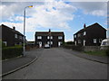
Kirkoswald Cul-de-sac
Just off Balvaird Road.
Image: © Billy McCrorie
Taken: 18 Apr 2012
0.05 miles
3
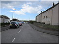
Merkland Place
From the junction with Balvaird Road.
Image: © Billy McCrorie
Taken: 18 Apr 2012
0.07 miles
5
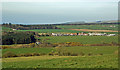
Kirkoswald Village View
Viewed from another square on the northern slope of Prop Hill.
Image: © Mary and Angus Hogg
Taken: 28 Mar 2019
0.07 miles

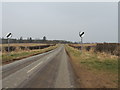
7
Welcome to Kirkoswald
With a haze moving in.
Image: © Billy McCrorie
Taken: 6 Mar 2013
0.08 miles
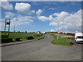
8
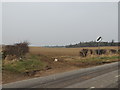
Farmland near Kirkland Hill
With Lagganhooly Cottage in the centre.
Image: © Billy McCrorie
Taken: 6 Mar 2013
0.09 miles
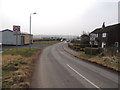
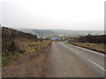
10
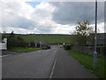
Balvaird Road
Looking down towards the Main Road (A77).
Image: © Billy McCrorie
Taken: 18 Apr 2012
0.09 miles